-
You are here:
Home
›
-
South Africa's cities
›
-
Cape Town
›
-
Cape Town map
Interactive City of Cape Town map (s), including
the metropolitan area and the Cape Peninsula
As you will see on the Cape Town map (s) below
that Cape Town is to be found right up north on the Cape Peninsula, in the south western corner of
the Western Province in South Africa.
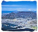
Bordered by Table Bay in the north and a cordon of mountains in the south, the city centre
lies in a kind of bowl that stretches into Table Bay.
This cordon of mountains, includes the well known Table Mountain, Devil's Peak, Lion's Head
and the Twelve Apostles.
They form the one end of the range of mountains stretching like a steep and rocky spine down the
length of the Peninsula from Cape Town to Cape Point.
The metropolitan area of Cape Town comprises more than 70 peaks with an average height of
300 meters.
The many suburbs of the city, of which many are situated on the Cape Flats, extend well beyond the
mountains encircling the city bowl. When navigating in and around Cape Town, there is the one and
only world renown beacon that makes it easy to find your way around and that is Table Mountain.
View Larger Map
An overview map showing you where Cape Town and the Western Province are situated.
Interactive Cape Town Map (s), Street Map of the City of Cape Town
Tips for navigating the maps on this page
- Click anywhere on the map to clear the "Directions" window
- The button in the left-hand top corner allows you to select a larger version of the
map.
- The button in the left-hand bottom corner allows you to change from street map to satellite
view and vice versa.
- The plus/minus button in the right-hand bottom corner allows you to zoom in and out. You
can zoom in to a detailed street map of any city or area that you select.
- Alternatively, put the mouse cursor on any location on the map that you want to explore and
click repeatedly with the left hand mouse button without moving the mouse.
- Moving the mouse cursor on the map with the left hand mouse button clicked in, will allow you
to move the map up and down and left and right.
- Click on the refresh button of your browser to return to the original map.
Interactive map of South Africa
View Larger Map
Tips for navigating the
maps on this page.
- Click anywhere on the map to clear the "view larger map" window
- The button in the left-hand top corner allows you to select a larger version of the
map.
- The button in the left-hand bottom corner allows you to change from street map to satellite
view and vice versa.
- The plus/minus button in the right-hand bottom corner allows you to zoom in and out. You
can zoom in to a detailed street map of any city or area that you select.
- Alternatively, put the mouse cursor on any location on the map that you want to explore and
click repeatedly with the left hand mouse button without moving the mouse.
- Moving the mouse cursor on the map with the left hand mouse button clicked in, will allow you
to move the map up and down and left and right.
- Click on the refresh button of your browser to return to the original map.
All you need to remember is that with Table Mountain at your back and Robben Island ahead of
you, looking across Table Bat towards the West Coast, you are facing (fronting) north. In
addition also keep in mind that Cape Town is split up into eight tourism regions:
City Centre,
Peninsula,
Atlantic Seaboard
, Southern Suburbs
, Helderberg
, Cape Flats,
Northern Suburbs
and the Blouberg
Coastline
Interactive Cape Town Map (s), Street Map of the
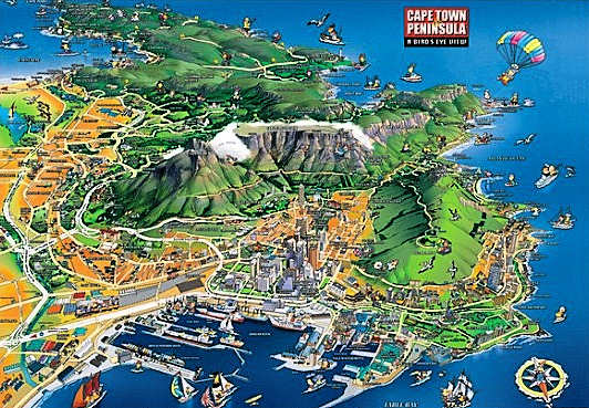
City of Cape Town, copyright © Mappery.com
Above is a Bird's eye view of Cape town and the Peninsula from www.mappery.com. Just
click
on the picture to see an enlargement. When you click on the enlarged picture again, it enlarges
even more.
Top of Page
City Centre,...
Encircled by Table Mountain at the back in the south, flanked east and west by Devil's Peak,
Lion's Head and Signal Hill and facing the Atlantic Ocean in the north, the Cape Town map will
show you Cape Town's city centre lying in a kind of basin-like enclosure, often referred to as
the City Bowl.
The City Centre consists of the CBD, Foreshore, Devil's Peak, Vredehoek, Oranjezicht,
Tamboerskloof, Higgovale and the Bo-Kaap. From its industrious foreshore, through the central
business district and up into the suburbs, Cape Town city is showing off its modern day
metropolitan characteristics amidst an abundant historical background.
Interactive Cape Town Map (s), Street Map of the City of Cape Town
Interactive map of the city centre of Cape Town including the Victoria & Alfred Waterfront, Green Point and Sea Point.
Interactive Cape Town Map (s), Street Map of the City of Cape Town
Interactive map of the city centre of Cape Town including the Victoria & Alfred Waterfront, Green Point and Sea Point.
Top of Page
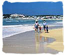
The Peninsula,...
Next to beautiful beachfront villages and relaxed suburbs, the Peninsula is the proud home
ground of Chapman's Peak Drive, one of the most scenically stunning passes in the world. Starting
at Muizenberg and going around the Peninsula, you will come past Muizenberg, St James, Kalk Bay,
Fish Hoek, Simon's Town, Cape Point, Scarborough, Kommetjie, Noordhoek, Chapman's Peak, Hout Bay,
ending up in Cape Town.
Towering 249 meters above the sea, making it one of the highest sea cliffs worldwide, Cape
Point is situated at the southern tip of the Peninsula. It is here where the warm Agulhas current
from the east coast and the cold Benguela current from the west coast meet each other, a sea area
that is known for its devastating storms, hence the name "Cape of Storms".
Interactive Cape Town Map (s), Street Map of the City of Cape Town
Interactive map of the Cape Peninsula
Interactive Cape Town Map (s), Street Map of the City of Cape Town
Interactive map of the Cape Peninsula
Top of Page
Atlantic Seaboard,...
Often referred to as Cape Town's "Riviera", the Cape Town map shows you the Atlantic Seaboard
region extending down from the & Waterfront just north of Table Mountain all along the west
coast of the Peninsula, ending just short of Hout Bay.
It includes some of the world's trendiest and most stunning beachfront locations, such as
Llandudno, Green Point, Oudekraal, Sea Point, Bakoven, Fresnave, Camps Bay, Clifton and Bantry
Bay, to name some of them. They compare with the best in the world. With the Twelve Apostles as
backdrop and facing the Atlantic ocean they are all linked by one of the world's most beautiful
scenic drives.
Interactive Cape Town Map (s), Street Map of the City of Cape Town
Interactive map of the Atlantic Seaboard
Interactive Cape Town Map (s), Street Map of the City of Cape Town
Interactive map of the Atlantic Seaboard
Top of Page
Southern Suburbs,...
The Southern Suburbs include Tokai, Woodstock, Constantia, Salt River, Bishopscourt,
Observatory, Wynberg, Mowbray, Kenilworth, Rosebank, Claremont, Rondebosch and Newlands,
extending outwards to the beautiful Kirstenbosch National Botanical Gardens and the grand manors
of the very rich between the vineyards.
The Southern Suburbs are primarily situated at the base of the Table Mountain National Park
mountain range that runs like rocky backbone from Signal Hill and Table Mountain along the length
of the Peninsula to Cape Point. It is also the area where the University of Cape Town can be
found.
Interactive Cape Town Map (s), Street Map of the City of Cape Town
Interactive map of the Southern Suburbs
Interactive Cape Town Map (s), Street Map of the City of Cape Town
Interactive map of the Southern Suburbs
Top of Page
Helderberg,...
The Helderberg region comprises Macassar and Lwandle, Gordon's Bay, Sir Lowry's Pass, Somerset
West and Strand. With the Helderberg and Hottentots Holland mountain ranges sloping down into golf
course estates and wine lands on the one side and a seaboard with stunning white beaches and warm
waters on the other side, the Helderberg valley is visually one of the most spectacular regions
in then Cape.
Interactive Cape Town Map (s), Street Map of the City of Cape Town
Interactive map of the Helderberg region
Interactive Cape Town Map (s), Street Map of the City of Cape Town
Interactive map of the Helderberg region
Top of Page
Cape Flats,...
The Cape Flats are large sandy plains situated between the Peninsula and the mainland. It is
thought that the Flats were covered by the sea in prehistoric times and that the Peninsula was an
island then.
The region includes Athlone, Philippi, Crossroads, Nyanga, Grassy Park, Mitchell's Plain,
Guguletho, Manenberg, Khayelitsha, Lansdowne and Langa. Most of the residents in this area are
colourd and black people as a result of the Apartheid era when large numbers of the non-white
population were forced to relocate here.
Interactive Cape Town Map (s), Street Map of the City of Cape Town
Interactive map of the Cape Flats area
Interactive Cape Town Map (s), Street Map of the City of Cape Town
Interactive map of the Cape Flats area
Top of Page
Northern Suburbs,...
Separated from the southern suburbs by the huge 250 hectares Century City commercial and
residential development, the Northern Suburbs region comprises Bellville, Century City,
Durbanville, Goodwood, Tyger Valley, Parow, West Beach, Welgemoed and Plattekloof.
They differ from the Southern Suburbs in the sense that they are more middle class type of
residential areas. Next to Century City, this suburban area also boasts Durbanville Wine Valley,
a number of great wine routes and the Grand West Casino.
Interactive Cape Town Map (s), Street Map of the City of Cape Town
Interactive Cape Town map of the Northern Suburbs
Interactive Cape Town Map (s), Street Map of the City of Cape Town
Interactive Cape Town map of the Northern Suburbs
Top of Page
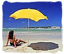
Blouberg Coastline,...
The Blouberg coastline includes Bloubergstrand, Paarden Island, Melkbosstrand, Milnerton, Table
View, Woodbridge Island, West Beach and Sunset Beach. Blouberg is most widely known for its 48
kilometers of bright sandy beaches and its magnificent panoramas of Table Mountain looking across
Table Bay. Regarded as an area with one of the highest growth rates in the Western Cape, it lies
en route from Cape Town to the West Coast.
Interactive Cape Town Map (s), Street Map of the City of Cape Town
Interactive map of the Blouberg Coastline region
Interactive Cape Town Map (s), Street Map of the City of Cape Town
Interactive map of the Blouberg Coastline region
Top of Page
-
Home
›
-
South Africa's cities
›
-
Cape Town
›
-
Cape Town map