|
|||||||||||||||||||||||||
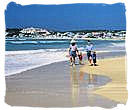
Enjoy South Africa 's climate, |
|||||||||||||||||||||||||


|
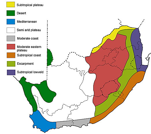
Climate Features
|
|
The Rainfall
|
|
The temperatures
|
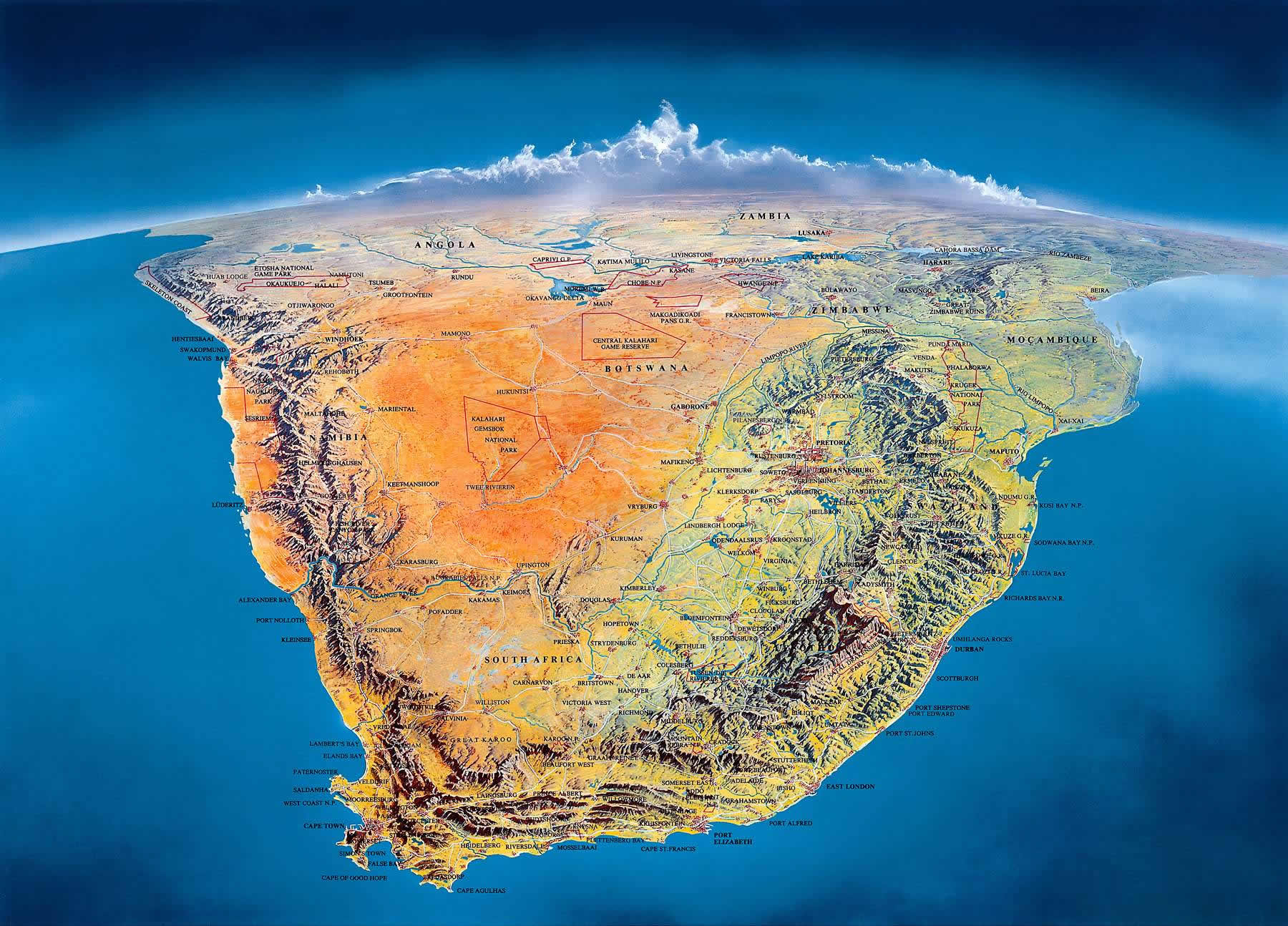
Interactive map showing view from space of the southern tip of Africa
Apart from a small region in the north-east with a desert like climatic environment, South Africa 's climate conditions as a whole range from mild and pleasant on the large interior plateau, subtropical in the north-eastern region, to Mediterranean in the south-western region of the country.
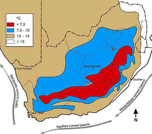
The warm north to south-flowing Mozambique-Agulhas current in the Indian ocean at the east coast and the cold south to north-flowing Benguela current in the Atlantic ocean at the west coast of our country, have an important effect on South Africa 's weather. The contrast in temperatures between these two currents, largely accounts for the striking differences in climate and vegetation between the east and west coasts.
Total overall average annual rainfall for South Africa is 464 mm, compared with an overall world average of 860 mm. In most of the country the rainfall occurs during summer. It is unpredictable and unreliable and is largely influenced by moist air moving in from the Indian ocean in the east and south east. Total rainfall is greatest in the east of the country and gradually decreases westward.
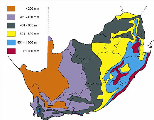
An exception to the overall rainfall pattern of South Africa 's climate is the south-western part of the Western Cape province. Here we find a typical Mediterranean climate with the rainfall occurring during the winter period, coming in from the Atlantic ocean. The average annual rainfall for this area is 515 mm.
Table of average annual rainfall figures.
| CAPE TOWN | 515 mm |
| JOHANNESBURG | 802 mm |
| DURBAN | 1009 mm |
| PRETORIA | 674 mm |
| BLOEMFONTEIN | 559 mm |
| PORT ELIZABETH | 1120 mm |
| KIMBERLEY | 414 mm |
| PHALABORWA | 747 mm |
| POLIKWANE | 468 mm |
| UPPINGTON | 189 mm |
Despite a latitude span of 13 degrees from south to north, average annual temperatures across the interior plateau are surprisingly uniform. There is hardly any increase in temperature from south to north, contrary to what one would have expected.
This is due to the increasing height of the interior plateau towards the northeast. The difference in average annual temperature between cape town at 17 degrees Celsius and Pretoria at 17,5 degrees Celsius over a distance of close to 1500 km for instance, is only half a degree Celsius.
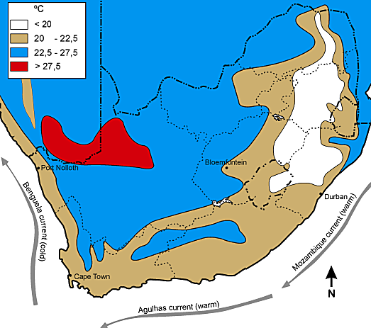
The effects of these two currents can even be seen at the narrow Cape peninsula, where water temperatures average up to 4 degrees Celsius higher on the eastern False Bay side, then on the western Cape town harbour side.
Temperatures above 30 degrees Celsius are fairly common in South Africa in summer. In regions like the lower Orange valley, the Karoo, the Mpumalanga lowveld and the north coast of kwazulu-Natal, they can exceed 38 degrees Celsius.
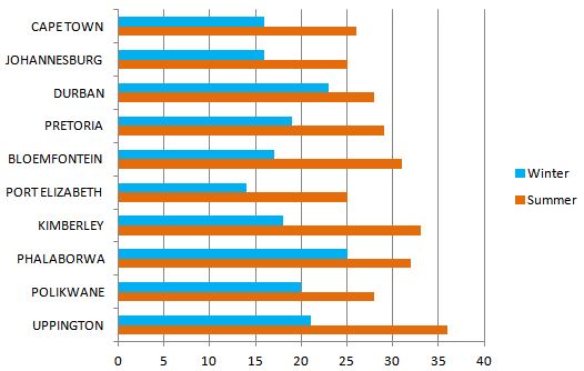
Table of average day temperatures in degrees celsius.
- You are here: Home ›
- South Africa's weather ›
- South Africa's climate